Media Contact
Email: [email protected]

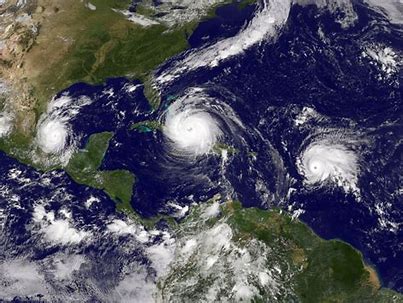
A study by the Colorado State University Tropical Meteorology Project predicts another busy hurricane season for 2018 with 14 named storms, seven hurricanes and three major hurricanes expected. Although less active than last year, the number of storms is slightly higher than the 30-year average of 12 named storms, six hurricanes and two major hurricanes.
Forecasters are wary to sound the alarm. They point to Hurricane Andrew, a category 5 hurricane that devastated South Florida in 1992. That year recorded only six named storms and one sub-tropical storm. In contrast, 2010 was a highly active year with 19 named storms and 12 hurricanes in the Atlantic. Just one tropical storm made landfall in the U.S. that season. Read the full story here.
According to NOAA’s Hurricane Research Division, “The U.S. averages one to two hurricane landfalls each season.” Last year, three category 4 hurricanes made landfall in the U.S. in Houston, South Florida and Puerto Rico. Damage from these storms is still impacting those regions, even as we close in on the 2018 hurricane season.
Coastal communities along the Gulf Coast and Atlantic seaboard would be wise to take precautions. A new study puts more than 40 million people living within areas at risk to floods. (Read our recent blog for more on that study.)
Long before a storm hits, building owners should contact the local emergency management agency to find out if any active flood warning systems are in place. The National Weather Service river-forecast centers prepare river-flood predictions and disseminate them to the public through NWS offices. Note these forecasts do not include many non-residential buildings near smaller streams. Property owners in those areas should work with local and state agencies to develop an adequate forecasting system.
Building owners who have taken steps to mitigate potential flood damage with dry floodproofing systems such as floodgates, floodpanels and flood doors should develop detailed flood emergency operational plans. Plans should include information on how floodproofing measures work during and after a flood event. For example, equipment that requires electricity, such as a sump pump, needs power throughout a flood event.
The plan should establish a chain of command, delineate personnel notification procedures, assign specific duties, describe locations for floodproofing measures, detail install and repair procedures, and include evacuation instructions. It should also include a periodic drill and training program, and a schedule for regular evaluation and updates. Owners should also schedule inspection and maintenance for all flood protected enclosures.
As the 2018 hurricane season approaches, no one knows for sure what impacts this year’s storms will have on the U.S. coasts. For those potentially in harm’s way, it’s best to heed the saying, “Hope for the best, prepare for the worst.”

People across the country were breathing a deep sigh of relief as the long and devastating 2017 hurricane season drew to a close. As cities across the storm-ravaged areas began the Herculean task of cleaning up and rebuilding, many city planners are looking beyond the immediate clean-up phase, and are determined to build in flood control measures that will help to lessen the impact of future storms.
Many innovative and cutting-edge technologies are being examined, and experts from around the world are being consulted. The Netherlands, with its centuries-old struggle against the sea, is particularly prominent as a place to begin looking for answers; here there is a wealth of expertise and battle-tested technology to be found. Now, many cities in the US are seeking to emulate the success of the Dutch people, and officials are finally beginning to understand that we are now facing a long-term challenge that will only get worse as climate change brings more frequent and more vicious storms.
Enlarged rainfall graphic for Hurricane Harvey in Southeast Texas. Author: David M. Roth; NOAA WPC
In Houston alone, there were over 8 million cubic yards of debris that had to be removed before full attention could be turned to flood prevention projects. There is also an acute housing crisis to be solved; a plan must be developed to shelter all those families that were displaced by the destruction of their homes. But even with these pressing and immediate concerns, planners in Houston are already seeking ways to dovetail flood control planning into every step of the recovery process. This is one of the lessons that the country of Holland has implemented well.
The most obvious flood mitigation project in Houston is to protect, widen, and prevent development around bayous and other water-detention areas; just as Holland has done for hundreds of years. Natural bayous and man-made reservoir projects can absorb a lot of storm water runoff, and if designed or improved with flooding in mind these can channel raging rivers of runoff into a desired direction. However, this obvious priority is too often challenged and circumvented. Houston, like all other growing cities in the US, is increasingly running out of real estate for new housing projects, even as the demand for housing is higher than ever. With the loss of so many homes to the hurricane comes a critical need for the replacement of these structures.
Houston planners understand that a high value must be placed on the flood protection value of its bayous, and they would be wise to resist any temptation to drain or build near these wetlands. But real life often has not worked this way in the past. Many developers have demonstrated a tendency to resist zoning laws and regulations that hamper their profits, and to look for loopholes and workarounds that can result in higher returns on their investments. The fact that skirting or getting an easement from zoning regulations can directly lead to floods and loss of the structures only means that there will be more business to be had in the rebuilding of the homes. Therefore, zoning decisions cannot be controlled or influenced by the construction industry!
Houston clearly cannot allow any further damage or encroachment of its precious retention lakes and bayous. City planners cannot permit developers to thwart or ignore zoning laws. This was starkly demonstrated during Hurricane Harvey, when communities that were built too close to the large retention lakes northwest of the city were submerged. Now, as Houston rebuilds, the priority is being placed on increasing the number of these critical artificial watersheds, augmenting and protecting the natural bayous, and on carving out stringent zoning regulations that are carved in granite.
Source:: FloodBarrierUSA

A team of UK-US engineers and scientists have presented their findings, after using cutting-edge technology to study flood patterns in the US. The results of the study, which were detailed at the 2017 American Geophysical Union meeting, appear to show that the current flood hazard maps used by the Federal Emergency Management Agency (FEMA) are woefully out of date and incorrect. The official FEMA flood hazard map is used to determine which properties must carry mandatory flood insurance, based on the officially-assessed risk. If the flood hazard zones are incorrectly identified, many properties may be left at risk of uninsured damage or destruction.
According to the team of researchers, there are approximately 40 million people now living within areas that have a 1% chance of flooding each year. This sounds inconsequential at first perusal, but this level of flood risk is also known as the ‘100-year floodplain’. As we know from recent disasters, the 100-year floods are happening with dreadful regularity in many parts of the US, often in locations that have never flooded before! If a property experiences flooding that was considered by FEMA to be improbable, it is likely that the property was not insured- in which case the owners stand to lose everything without compensation- the funds needed to rebuild. This scenario can destroy lives as well as houses.
As the map above shows, as of April 2017, much of the country has already received updated flood maps in the form of preliminary or effective Flood Insurance Rate Maps (FIRMs). Source: FEMA.gov
Although the new study estimates 40 million people living inside the risk zone, FEMA estimates only 13 million people are living within the 100-year floodplain … a substantially smaller risk pool. This means that as many as 27 million people may be at risk of being underinsured or completely uninsured for flood damage because their property has not been determined by FEMA to be at risk. It may be that many of these people are living with a very false sense of security!
Why do the FEMA numbers differ so drastically from the results presented by the UK-US scientists? This is a question of profound importance to the many millions of people who may be risking disaster, as well as to the engineers and scientists at FEMA who compile the statistics to produce the official flood hazard maps. According to the scientists who were involved with the study, FEMA concentrates too heavily on coastal flooding, and not enough attention is given to floodplains close to rivers, which can be subject to flash flooding during heavy rainfall. The new study was conducted with improved scientific techniques that identified every possible flood zone along US rivers, and here they simulated heavy precipitation events. The results of these simulations are a wake-up call to those who own property in these areas.
So far, the results of this alarming new study have not been utilized by FEMA officials, but the agency is aware of the study and is taking a look at the newly-released data. If the results are embraced and translated into action, many millions of people in the US will find themselves suddenly in need of expensive flood insurance. That would be a hardship, to be sure. But with trillions of dollars worth of assets currently unprotected, an even greater hardship looms as a very real possibility.
Source:: FloodBarrierUSA
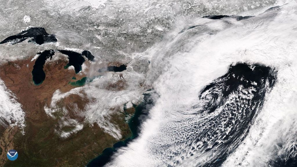
March 2018 roared in like a lion on the East Coast with four nor’easters in just three weeks. These storms brought heavy rain, snow, high winds, coastal flooding and beach erosion to major cities including Baltimore, Philadelphia, New York and Boston.
While hurricanes are notorious for their destructive force, nor’easters deliver the most flooding and damage to the Northeast. Superstorm Sandy, a hurricane, produced the largest storm surge on record for New York City. However, nor’easters caused 88 of the top 100 storm surges in that area, according to a study by Rutgers University-New Brunswick scientists.
In Boston this year, nor’easters hit especially hard with catastrophic flooding that destroyed businesses and homes along the coast. The city recorded a historic flood crest of 15.16 feet during a January storm, and a 14.67 crest in March, the third highest on record for that city.
“There is a tendency to misinterpret the worst effects of a nor’easter. They are usually associated with heavy snow that can shut down major interstates, ground flights and reduce visibility to near nothing. Those effects are certainly crippling, but much of the lasting damage is along the coast, where entire beaches wash away and hundreds — maybe thousands — of homes flood.” (“Major nor’easter will inflict destructive wind and coastal flooding on northeast,” Washington Post, 2/28/2018)
According to The Weather Channel, “A nor’easter is an area of low pressure along the East Coast of the United States that typically features winds from the northeast Atlantic Ocean.” In the Northeast, most people think of them as winter storms because of their frequency in that season and tendency to deliver significant snowfall.
The classic nor’easter, referred to by meteorologists as Miller Type-A, forms along the Gulf or East Coast and travels north along the coast. A second type, Miller Type-B, starts in the Midwest, moves east and then reforms along the east coast where it resembles the classic nor’easter. The March storms of 2018 followed the Miller Type-B track.
According to Jeff Masters, a meteorologist and blogger with Weather Underground, nor’easters are fueled by the collision of cold, dry air from the north and moist air from the ocean. Hurricanes have a warm core and need tropical water for energy. In contrast, nor’easters have a cold core and thrive in the colder waters of New England, slowly strengthening along the coast where hurricanes typically die.
The swirling cloud images of nor’easters and hurricanes taken from space may look alike at first glance, but that is where the similarities end.
Nor’easters are not tropical storms. They generally form between Georgia and New Jersey, while hurricanes typically develop in the tropics, first as thunderstorms off the coast of Africa or as low-pressure systems in the Atlantic.
Nor’easters occur 20-40 times a year in the Northeast. They are more common between October and April, but can form anytime of the year. In comparison, a hurricane makes landfall in the Northeast once every five years. Nor’easters are not only more frequent, but at least two a year are considered severe.
Nor’easters are bigger storms. Typically 3-4 times the size of a hurricane, nor’easters are the largest weather systems in the world and can impact a third or more of the U.S. at one time (“Hurricanes vs. nor’easters. What makes them different?,” Washington Post, 2/13/13). In comparison, a typical hurricane is 300 miles wide.
Nor’easters are slow. They move slower than hurricanes, often impacting one stretch of coastline over several days and tide cycles. A single hurricane may cause more damage than a single nor’easter. However, the frequency and duration of nor’easters can cause billions of dollars in cumulative damages from repetitive coastal flooding, power outages and prolonged wind and waves that erode beaches.
As recent storms have proven, nor’easters pack a punch with the potential for flooding on an epic scale. Residents in coastal communities in the path of these frequent storms should take pre-emptive steps to minimize flood damage from the next nor’easter. It’s not a question of if, but when.
For more information on flood mitigation, visit www.floodpanel.com.