Blog
Media Contact
Email: media@floodpanel.com

Eta Floods Florida After Very Wet ‘Dry Season’
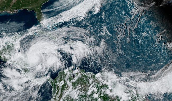
Photo: Satellite imagery of Hurricane Eta. It was upgraded to a major hurricane by the National Hurricane Center on Monday, November 2, 2020. It was expected to dump 35 inches of rain in some isolated areas of Nicaragua after making landfall. NOAA
By the time Hurricane Eta arrived in South Florida, the stage was set for a flooding disaster. Although the fall season generally ushers in dry, hot weather, this year has been an anomaly. Unlike the rest of the United States, Florida has two seasons: the wet season and the dry season — which normally arrives around mid October. In 2020, however, the long wet season has been unusually prolific with rain, and the underground water tables are running very high. This is often considered a good thing, especially since the year 2020 is expected to present a set of La Niña weather conditions, which can sometimes lead to drought conditions. The La Niña expected for this year is projected to be on the stronger side, but because of the ample precipitation throughout the summer, droughts are not expected to plague Florida, in spite of this upcoming strong La Niña.
While all that summer rainfall is a boon to farmers and wildlife, it also means that the ground throughout much of South Florida is fully saturated. However, as the region enters its dry season, the record-shattering 2020 hurricane season is not yet over — as this season generally remains active until the very end of November. The threats posed by the confluence of super-saturated ground and a hyperactive hurricane season was brought home on November 9, when the remnants of Hurricane Eta arrived in the area.
By the time Eta made landfall in Florida it had already lashed through Central America and had weakened into a tropical storm. This meant that the area was spared the destructive gale-force winds that had flattened parts of Nicaragua, but even in the absence of high-velocity winds, Eta still inflicted a lot of damage in Florida. Tropical Storm Eta made landfall in the Florida Keys, a uniquely vulnerable part of the United States. Very low-lying and tenuously attached to the mainland by aging bridges, the Keys are often depicted in post-storm news photos of horrifying damage and fully submerged streets. Sure enough, photos from the Keys once again illustrated the major damage and swamped homes left behind when Eta had moved through the area.
Falling atop the 14” of rain that had already inundated the area during the previous month, another 12” of rain was recorded in a single day across parts of southern Florida. This was a disastrous amount of precipitation, and it could not have come at a worse time. Even though residents and local officials were prepared for the arrival of Eta, there was very little that could be done to prevent or alleviate the flooding. Before the first drop of rain arrived in the area, sand bags had been filled and placed, flood barriers had been installed, levees and other flood mitigation measures had been readied — but there was nevertheless a massive flooding event across the region. The water simply had nowhere to go.
After the rains had moved through, giant vacuum trucks moved through the zone, sucking up all the excess water that had stranded and stalled cars, and filled homes. Some people who had attempted to continue driving through the flooded streets ended up submerged in canals or dangling from rain-slicked bridges. As the soggy ground was presented with even more water, massive banyan trees were dislodged as their root systems became unstable in the loosened earth. Floridians were somewhat lucky that Hurricane Eta had weakened into a tropical storm by the time it made landfall in that state, but very few residents of the Keys felt ‘lucky’ as they slogged through the massive cleanup of their homes and businesses.

