Page 3
Media Contact
Email: media@floodpanel.com
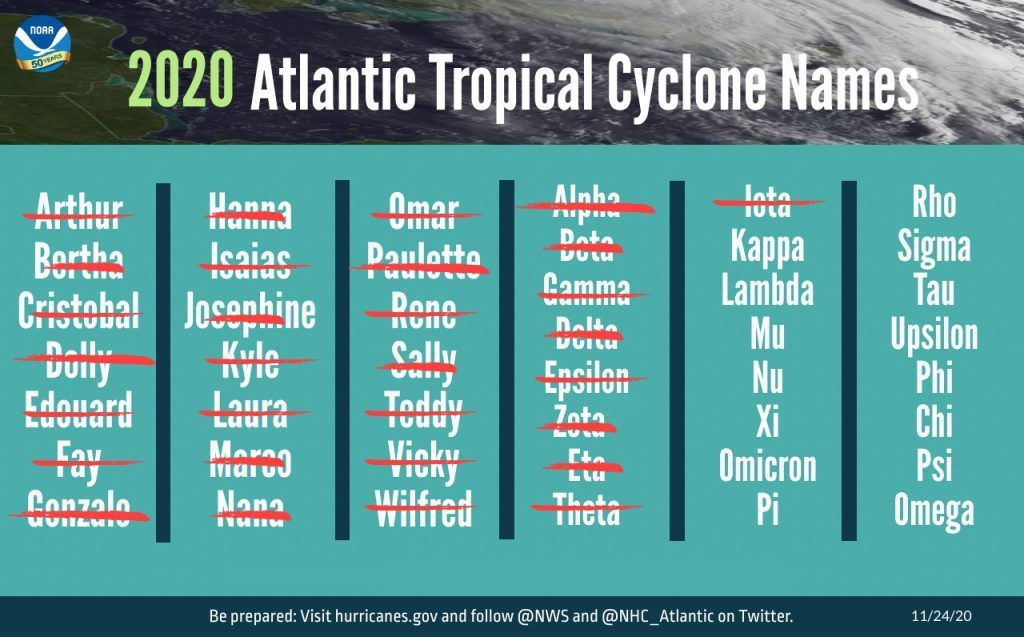
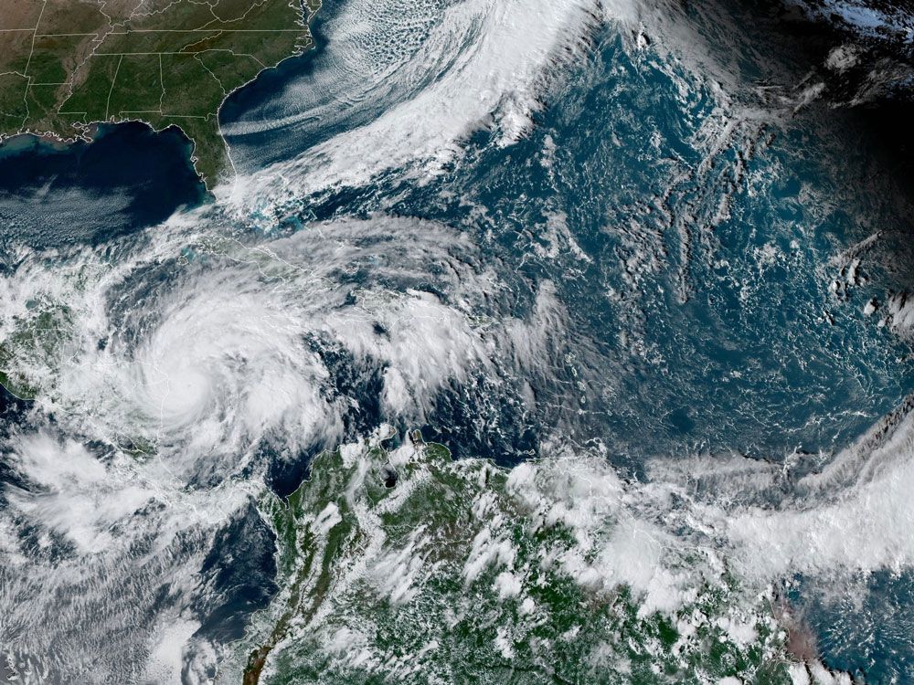
Photo: Satellite imagery of Hurricane Eta. It was upgraded to a major hurricane by the National Hurricane Center on Monday, November 2, 2020. It was expected to dump 35 inches of rain in some isolated areas of Nicaragua after making landfall. NOAA
By the time Hurricane Eta arrived in South Florida, the stage was set for a flooding disaster. Although the fall season generally ushers in dry, hot weather, this year has been an anomaly. Unlike the rest of the United States, Florida has two seasons: the wet season and the dry season — which normally arrives around mid October. In 2020, however, the long wet season has been unusually prolific with rain, and the underground water tables are running very high. This is often considered a good thing, especially since the year 2020 is expected to present a set of La Niña weather conditions, which can sometimes lead to drought conditions. The La Niña expected for this year is projected to be on the stronger side, but because of the ample precipitation throughout the summer, droughts are not expected to plague Florida, in spite of this upcoming strong La Niña.
While all that summer rainfall is a boon to farmers and wildlife, it also means that the ground throughout much of South Florida is fully saturated. However, as the region enters its dry season, the record-shattering 2020 hurricane season is not yet over — as this season generally remains active until the very end of November. The threats posed by the confluence of super-saturated ground and a hyperactive hurricane season was brought home on November 9, when the remnants of Hurricane Eta arrived in the area.
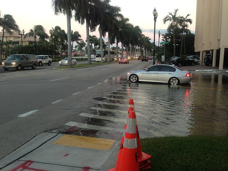
By the time Eta made landfall in Florida it had already lashed through Central America and had weakened into a tropical storm. This meant that the area was spared the destructive gale-force winds that had flattened parts of Nicaragua, but even in the absence of high-velocity winds, Eta still inflicted a lot of damage in Florida. Tropical Storm Eta made landfall in the Florida Keys, a uniquely vulnerable part of the United States. Very low-lying and tenuously attached to the mainland by aging bridges, the Keys are often depicted in post-storm news photos of horrifying damage and fully submerged streets. Sure enough, photos from the Keys once again illustrated the major damage and swamped homes left behind when Eta had moved through the area.
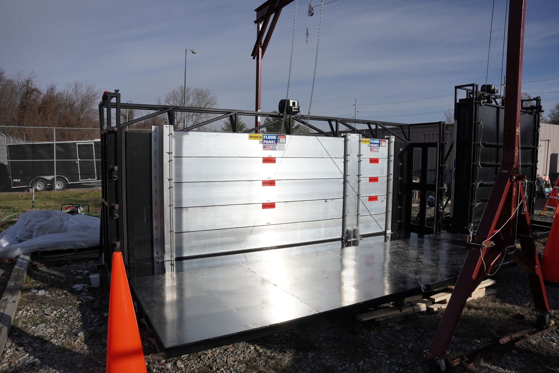
Falling atop the 14” of rain that had already inundated the area during the previous month, another 12” of rain was recorded in a single day across parts of southern Florida. This was a disastrous amount of precipitation, and it could not have come at a worse time. Even though residents and local officials were prepared for the arrival of Eta, there was very little that could be done to prevent or alleviate the flooding. Before the first drop of rain arrived in the area, sand bags had been filled and placed, flood barriers had been installed, levees and other flood mitigation measures had been readied — but there was nevertheless a massive flooding event across the region. The water simply had nowhere to go.
After the rains had moved through, giant vacuum trucks moved through the zone, sucking up all the excess water that had stranded and stalled cars, and filled homes. Some people who had attempted to continue driving through the flooded streets ended up submerged in canals or dangling from rain-slicked bridges. As the soggy ground was presented with even more water, massive banyan trees were dislodged as their root systems became unstable in the loosened earth. Floridians were somewhat lucky that Hurricane Eta had weakened into a tropical storm by the time it made landfall in that state, but very few residents of the Keys felt ‘lucky’ as they slogged through the massive cleanup of their homes and businesses.
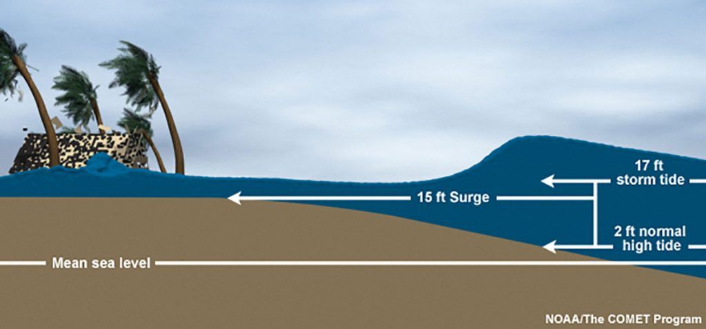
Click graphic above to enlarge: Storm surge is an abnormal rise of water generated by a storm, over and above the predicted astronomical tides. Storm surge should not be confused with storm tide, which is defined as the water level rise due to the combination of storm surge and the astronomical tide. This rise in water level can cause extreme flooding in coastal areas particularly when storm surge coincides with normal high tide, resulting in storm tides reaching up to 20 feet or more in some cases. Source: https://www.nhc.noaa.gov/surge/
We have mentioned the phenomenon of storm surge many times in this blog series, and now storm surge is again in the news with the arrival of hurricane after hurricane during this record-setting year. But what exactly is storm surge, and why is it so dangerous?
The simplest explanation is that storm surge is the sudden rise in sea level that happens during a hurricane, cyclone, or a particularly powerful storm. Although it is often described as a ‘wall of water’ in news accounts, it rarely appears this way in reality. Most often, the sea water will arrive with the winds of the hurricane, pushed forward by the gusts. The speed at which the water level rises can be astonishing, and this is why storm surges are so dangerous. At one moment, a person can be standing on dry land- in a location thought to be well inland from the sea- and at the next moment the person finds themselves waist deep in swirling, debris-filled seawater. This can happen with incredible speed and suddenness!
Many people do not understand this hazard, even those who may have lived near the coastline all their lives. When unprepared people hear that a 6-foot storm surge is expected, they often envision that the usual high tide mark will be extended by six feet. They erroneously picture the normal coastline, but just six feet higher into the beach zone. This can be a deadly mistake, because a 6’ storm surge means something far more dangerous!
To get a more accurate picture of a storm surge, you would need to know that a 6’ storm surge means that water will cover a given area to a DEPTH of 6’. The actual spatial incursion of the storm surge depends on many factors such as topography, obstacles, wind direction, and other variables. In general, meteorologists produce storm surge charts that can indicate how far inland this 6’-deep surge will extend, so that people can evacuate in a timely manner.
Evacuation is the only safe choice in a zone where a large storm surge is predicted. Taking our example of the 6’ storm surge, let’s imagine being confronted by the very sudden arrival of a six foot depth of water. A cubic yard of water weighs over 1,700 pounds, so a 6’ surge introduces twice that much- over 3400 pounds of water pushing its way towards you, your car, or your house. Even a very well built house on a fortified foundation can have trouble withstanding that amount of force. A person on foot has no chance at all to resist, and even a sturdy SUV will soon topple. In fact, most vehicles have trouble withstanding even a 1’ surge of water.
Clearly, the best plan of action is to evacuate as soon as possible when a storm surge is predicted. The surge can arrive well ahead of the hurricane ‘making landfall’, at times arriving a day or more before the actual storm. Waiting to ‘see what happens’ only means that you will lose precious time to make your escape, during a time when many other vehicles will be clogging the escape routes. Many people think that the forceful gales of the hurricane are the thing to be feared, but in fact it is the storm surge that kills that vast majority of storm victims who live near the coastline. For this reason, it is critically important to consult the reports- not only for expected landfall times- but also for the expected storm surge zones. Having important belongings and documents collected and packed, having a ‘go bag’ by the door, securing pets in carriers, bringing food, lots of clean water, clothing, toiletries, and bedding for everyone in the house- these are all tasks that need to be completed well ahead of a hurricane, because the most dangerous part of the hurricane may well arrive a day or two before the hurricane itself.
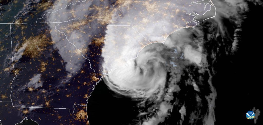
PHOTO: A visible NOAA GOES-16 satellite image of Hurricane Isaias as it approached the U.S. East Coast at 7:46 p.m. ET, August 3, 2020. (NOAA)
At the beginning of June, the 2020 hurricane season was already looking busy, with at least nine major ‘named’ storms predicted by the National Oceanographic and Atmospheric Agency (NOAA). As of the middle of August, these nine named storms have already come and gone, and the tenth, Josephine, is forming on the horizon. With a full three and half months left in the season, we have already exceeded the predicted number of storms for the entire season. This is an indication that we may be in for a record-smashing year.
According to records kept by NOAA, most years will suffer an average of 10-12 named storms, of which an average of 6 become hurricanes. Of those 6 hurricanes, 2-3 will become major hurricanes- meaning Category 3 or higher. In preparation for the season, NOAA prepares and publishes the names for that year’s expected storms, so that weather professionals can be prepared and coordinated across the affected regions.
The names for the storms come from a list that is maintained by the World Meteorological Organization (WMO), and this list is strictly proscribed and inflexible. The names are assigned in order, alphabetically, with male and female names alternating. There are six lists of names, which are used in rotation, and after six years the cycle of names begins again. There are no names assigned to the letters Q,U,X,Y, and Z, so there are 21 names prepared at the start of each hurricane season. Very, very rarely is this list of 21 storm names inadequate to cover a year’s worth of named storms. One such year was 2005.
The year 2005 was a record-breaker in many ways. That year, a full 28 storms were strong enough to be assigned a name from the WMO, among them the infamous Hurricane Katrina. Storms like Katrina cause a rare alteration to the strict list of storm names, because these monster storms are so deadly and costly that using the name again would be painful to its victims, even six years later. In this rare case, the name of the notorious storm is permanently retired.
The other reason that the year 2005 was a record-breaker is that with 28 named storms, it used up all the names available for the year, and then some. In the event of this very infrequent circumstance, there is an ‘overflow list’ of other names derived from the Greek alphabet. When we hear of storms named Alpha or Beta, we know that this is not a normal year!
For this current year of 2020, with a global pandemic causing death and disruption across the planet, there are as many as 24 named storms considered likely. As the hurricane season extends from June 1 through November 30, we are currently only 1/3 of the way through the season, with ten storms already named! This means that we may have Hurricane Gamma on our hands by the end of the season. Any year in which the NOAA has to dip into the ‘Greek names’ is likely to be a bad year for anyone living or owning property in the hurricane zone- and we can only hope that another storm like Katrina will not appear in this already challenging and deadly year.