Call Us Today - 1 (860) 222-3055
Call Us Today - 1 (860) 222-3055
Page 19
Media Contact
Email: media@floodpanel.com
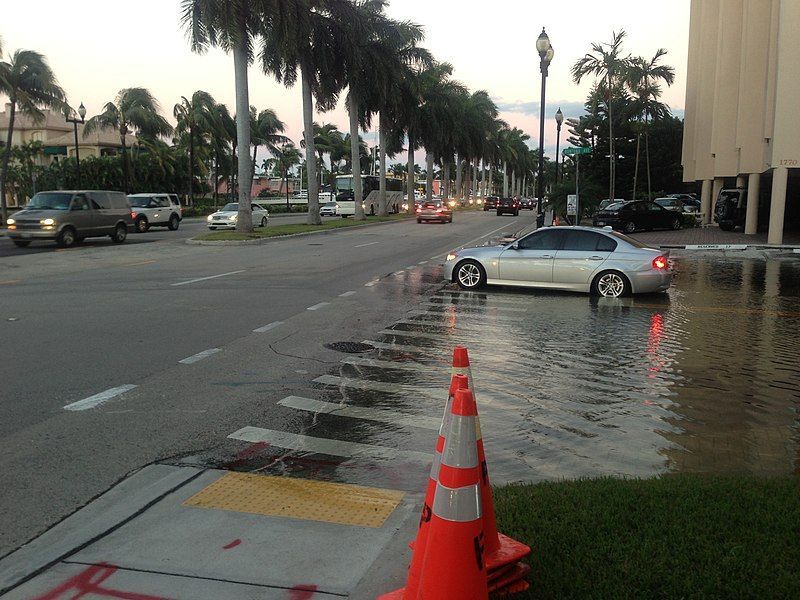
It is not surprising to hear about a flood in the state of Florida — this scenario takes place on a regular basis. However, now there is a new kind of flood that is taking place: an insidious and never-ending flood that is threatening the entire state. This new and dangerous flood comes in the form of an ongoing encroachment of the sea into the Everglades.
The Everglades is a huge wetlands that once stretched from Orlando to the southernmost tip of the state. Over the past century, about half of the Everglades has been drained, filled, and reclaimed for use as farmland or residential development. What remains of the original Everglades is now largely protected, and it still covers a vast area of over 1,500,000 acres, or 2400 square miles. Since the 1970’s, the public has become educated about the importance of protecting this huge ecosystem, and direct damage and encroachment from human action has slowed considerably.
Source: Florida International University
Unfortunately, this does not mean that the Everglades is now completely unharmed by human activity. Damage to the ecosystem is continuing in many ways; for example in the form of pollution from pesticides and agricultural chemicals. But even more alarming than these pollutants is the rapid and seemingly unstoppable encroachment of the sea into the Everglades — this is a threat that has the potential to kill the entire system.
The Everglades begin near Orlando, where water from the Kissimmee River flows south into shallow Lake Okeechobee. During periods of heavy precipitation, Lake Okeechobee will overflow, and this forms an extremely wide and slow-moving river that empties into the Florida Bay. This river is not a conventional one — it does not have banks or swift water flow, nor does it even have much visible water surface. The Everglades has been called a ‘river of grass’, and this description deftly sums up its appearance. The vast ‘river of grass’ flows very slowly over a shelf of porous limestone, which is covered by a large amount of peat. The peat supports the plant life, which is mostly sawgrass, and the tangled root systems of these important plants help to hold the whole system together.
Recently, scientists have been finding that global sea level rise is pushing salt water into the Everglades system. As the sea water encroaches inland, it enters the limestone foundation that lies under much of the state, and it rises up under the Everglades. The saline water comes up from the porous limestone and seeps into the peat that supports aquatic plants and animals, creating conditions that kill off that life. If left unchecked, this development could finish off a national treasure: the great Everglades.
Even more devastating than the loss of the Everglades, and directly tied to its fate, would be the pollution of the Biscayne aquifer that lies below the Everglades. This aquifer is absolutely essential to support human habitation and agriculture in the state of Florida, with 90% of the freshwater needed to support communities and farming coming from this source. Now, however, as the Everglades is threatened by saltwater, the aquifer beneath is also at grave risk of pollution. One idea to hold off the encroachment of the saltwater is to put more fresh water from the aquifer into the Everglades, in order to hold back the salt. Today, the restoration and protection of the Everglades is critical not only to the flora and fauna that live there, but to the millions of human residents who depend on the Biscayne aquifer as their only source of fresh water.
Source:: FloodBarrierUSA
During the first week of March 2016 an unusually prolific weather event pummeled the area near the Texas-Louisiana border, smashing rainfall records as well as homes, bridges, and other infrastructure. In some areas, over two feet of rain was recorded from this single event- an incredible amount that wreaked destruction and put many lives at risk. The massive amounts of rain put tremendous pressure on local reservoirs, and engineers were forced to open the gates, sending huge plumes of water downstream. For example, at the height of the water release operation at the Toledo Bend Dam, water was released at the astonishing rate of 1.5 million gallons per second!
Precipitation levels recorded on March 11th, 2016.
The amount of water released at the Toledo Bend Dam was record-breaking- never before in the 50-year service life of this dam had that much water been released. As might be expected, all that liberated water rushed downstream at perilous speeds, and resulted in river flooding throughout the area. Homes, businesses, farmlands, bridges, and roads were washed away. Some people, who may have little understanding of dams and reservoirs, questioned why the water was released, when so many people living downstream were grievously affected. The simple truth is that had engineers not released the pressure on the dam, the entire dam might have collapsed, causing a disaster that could have dwarfed the infamous Johnstown Flood in terms of destruction and loss of life.
As it was, the water that was released from the dam caused widespread flooding and destruction, and this was in addition to the flooding that was already happening before the sluice gates were opened at the dam. All the rivers in the region were already nearing record crest levels, and after the dam water arrived, many rivers not only broke crest records, but smashed them. The Sabine River, which flows along the border of Texas and Louisiana, achieved a crest level a full five feet above the previous records, which went back to the year 1884.
This particular storm only added to what has been a miserable year for the region, which suffered over a dozen major flash flooding events. Almost half a dozen reporting sites have recorded precipitation levels of 2 feet or more above normal levels for the year. This is an incredible amount of extra rain, and the region has suffered greatly in terms of loss: homes, roads, bridges, businesses, and agricultural ruin will require much effort and funding in order to return to normal.
The cause of the rainfall during the first week of March was identified as a massive storm system that moved slowly across Mexico, then skirted around the coast of the Gulf of Mexico, all the while picking up moisture- which it dumped on the Mississippi Valley region. This region is well accustomed to enduring massive storms, but the rainfall amounts recorded this month crushed records in many spots. The weather station near Monroe, Louisiana recorded the highest amount of precipitation, at just under 27″ for the duration of the multi-day storm. Overall, the storm brought more precipitation that has ever been experienced in living memory, and perhaps will become known as the infamous Storm of March 2016; a storm by which future tempests will be measured.
Source:: FloodBarrierUSA